Tuesday, January 31, 2012

The Great Range


"Climbing is the lazy man's way to enlightenment. It forces you to pay attention because if you don't, you won't succeed, which is minor - or you may get hurt, which is major. Instead of years of meditation, you have this activity that forces you to relax and monitor your breathing and tread that line between living and dying. When you climb, you always are confronted with the edge. Hey, if it was just like climbing a ladder, we all would have quit a long time ago."
- Duncan Ferguson

Hiking is a very spiritual sport. In baseball and football, you're facing the other team; in tennis and wrestling, you're trying to defeat another person. But in hiking, there is no one to defeat, and you don't "conquer" the mountains unless they allow you that honor. There's a lot of honor and respect in this noble sport: you honor and respect the mountains, and you thank them for allowing you to share their beauty. Moreover, it's about respecting yourself, knowing your bounds, and pushing yourself - it builds self-discipline so that you don't push your limits to the point of danger. The point of hiking is not to win, it's to grow and experience.

While working at Camp Pack Forest, we hiked almost every day. By the end of the summer, I was in the best shape of my life. I had a short break towards the end of the season, and I wanted to do something memorable. My friend Keith and I had been poring over our High Peaks topographical map and guide book, as well as my favorite go-to book about that area: Exploring the Adirondack High Peaks. We wanted to do Gothics because from everything we had heard while researching, it was a gorgeous hike with one of the best views in the Adirondacks; however, it was in the middle of The Great Range, a mountain range consisting of six High Peaks: Lower and Upper Wolf Jaws, Armstrong, Gothics, Saddleback, and Basin. It did not seem prudent to us to do the middle peak in this range, due to the way the trails were set up around it, without doing the others. So, we decided to be "epic" and "gnar-tastic" (words we actually used haha) and do all six in one day!

We got off work after dinner at Pack Forest, around 6 pm, and headed right up to begin our hike from The Garden trailhead. Our objective for the first night was Wolfjaw Leanto, about 4.5 miles in. Beginning so late, it was not long until we were hiking in darkness, though. This was the first time I had backpacked at night :) Around three miles in, we reached a trail junction just before Johns Brook Lodge and Johns Brook itself. After signing it, we headed left towards our destination, soon crossing a new suspension bridge.


Hiking in at night, after a long day at work, we became pretty tired. We became a little disoriented, due to the darkness and because neither of us had been on this particular trail before, and we thought that we had possibly passed the leanto without noticing it. Rather than exhaust ourselves looking for it, since even then we might not have found it (since we didn't know what it looked like), we decided to make camp in a small clearing off to the right of the trail and start from there the next morning.

From our research, we had gathered that there is no reliable source of water once you enter the Great Range. After breakfast, we filled our bottles at a nearby stream - Keith filtered 3 liters and I brought 3 1/2 liters, or about a gallon, for what should have been about a 17 mile hike from our present location, over the range, and ending at Slant Rock, our destination for the night. Beginning down the trail, we soon encountered Wolfjaw Leanto on the left side and continued past it, soon coming to a trail junction. You head left here to summit Lower Wolfjaw and then have to descend back to this point to journey over the rest of the range; the roundtrip to Lower Wolfjaw is just one mile.
The jaunt up Lower Wolfjaw is steep and sandy. With full packs on, something I was not accustomed to in the High Peaks since I normally set up a base camp and day hike from there, it was somewhat more difficult than I had anticipated, our packs trying to drag us backwards. We reached the wooded summit with some effort and took a short break to down some water and eat a granola bar or two, already wondering what we had gotten ourselves into. Although the summit is wooded, you get a good view out over Johns Brook valley and can see down the length of the Great Range, with Marcy looming over and behind it.

We descended Lower Wolfjaw and began our way up Upper Wolfjaw, knowing that time was one our biggest enemies on this day.  When we neared the summit of Upper Wolfjaw, another "eh" peak, we saw storm clouds skirting us, seemingly over Giant Mountain, and echoing rumbling thunder through the mountains. We had to pause for a short time to try to determine where the storm was moving and if it would be safe to be on an exposed summit. After determining that the storm was actually moving away, we continued onward.

The spine of the Great Range began to show its difficulty between Upper Wolfjaw and Armstrong Mountain. Most trails near summit in the High Peaks have their difficult sections in which you have to scamper up bare rocky outcroppings or somehow finagle your body up an 8-foot boulder. Since much of the range's ridge is above 3,500 feet, most of the ridge was like an extended trail full of these difficult sections, and while wearing a full pack, not only does the weight pulling on you make this harder, but so does the awkwardness of it protruding behind you. Nevertheless, we soon reached Armstrong Peak, which has a very beautiful summit with your first expansive views.

A few minutes after we arrived at Armstrong, it seemed the entire community of hikers descended upon us like horseflies. After getting one to snap the picture above, we gathered our bags and pressed onward, motivated by the knowledge of having already completed three peaks. Maybe this wouldn't be so hard after all! Wrong.

The High Peaks have a way of making you sorry for even the slightest notions of overconfidence.


From Armstrong: Majestic Gothics, our next objective

Between Armstrong and Gothics is the only trail that bisects the Great Range from Johns Brook valley. Most of the hike between Armstrong and Gothics is not too difficult.  By this part of our journey, we had acquired a walking rhythm that required no thinking - it was as natural as breathing. You dip only slightly until about a half mile from Gothics, then ascend steeply to the summit, as Gothics is slightly more than 400 feet taller than Armstrong. The books don't lie, though: the view from Gothics' summit is spectacular. Only when we paused to take a break on the summit did I start to realize that I was beginning to tire. We took a break to refuel, and Keith examined our map and the progress we were making in relation to the time of day, while I searched for the summit button and one of Verplank Colvin's original copper summit button bolts, which he did long before the USGS Survey (I didn't find them unfortunately. Phooey!), and marveled at the beautiful alpine gardens.
Notice how much more tired I look in this summit pic than on Armstrong's?


As we were leaving Gothics, we met a man coming from the other direction. He was incredibly unprepared for where he was; I was surprised that he had made it this far, even. He wore blue jeans, a simple white undershirt, and flat-soled sneakers. He had a walking stick, but no backpack, no map, and only one bottle of water, which was dry by this point. He had no idea where he was going. I was legitimately concerned that he was going to hurt himself. Though I myself was running low on the water I had carefully rationed, we could not let this man pass without trying to help. So, I poured half a liter of my water into his bottle (wincing inside as I did so) and Keith gave him a few iodine tablets (for purifying water), and we directed him to the trail junction down to Johns Brook, the nearest source of water, a well traveled route, and there is a ranger station close by.  The trail junction was not far, but the actual distance to Johns Brook would take him at least an hour to travel.

It's at this point that the journey enters the realm of epic stories.

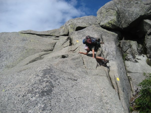
The descent down the back side of Gothics is incredibly steep; so steep, in fact, that there are steel rods pounded into the rock face and a steel cable running through their eyeholes, so that you may lower yourself with the cable, as a spelunker might rappel down into a cave. This part would have been scary had I been dayhiking with suction cups attached to my appendages; while carrying a pack that weighed around 40 pounds, it was terrifying. I can't even begin to fathom doing this in the winter.
Most of it is a lot steeper than this. However, this is the beginning, the only place I could stand and take a picture.

After lowering yourself down off the bare rock using the cable, you continue to descend steeply.  The area between Gothics and Saddleback is a deep col, which is disheartening to a tired hiker who knows he must then ascend that same distance to reach the next summit. Nevertheless, we pushed onward. Our time was growing short since the descent of Gothics was slow and took up more time than we had planned. You can have as many plans as you want in the High Peaks, but sticking to them is nearly impossible. After a while, you just kind of say "Screw the plans" and keep putting one foot in front of the other...

We climbed steeply to the next mountain, Saddleback, and were on the summit before I knew it. I had thought Gothics would be the highlight of the range, but Saddleback was actually my favorite. It's a jewel, a diamond in the rough. Being situated between Basin and Gothics, with no direct trail access, to only way to reach it is to go over one of the two mountains. The view from Saddleback is astounding, though. You can see the entire Johns Brook valley, like you can in the rest of the Great Range. However, your views of Armstrong and the Wolfjaws is now obscured by Gothics. Looking Southwest, you get a great view of Lower and Upper Ausable Lakes. My favorite view was North, however, where you are confronted with the epic facade of Basin and monumental Marcy peeking over the top, appearing ominous and intimidating. The view simply took my breath away. In fact, it's the picture I use as this blog's header! :)

I had thought the descent of Gothics was rough, but the descent of Saddleback is even tougher. I had heard about the steel cable on Gothics, but had heard nothing about the difficulty of Saddleback, so while I was able to mentally prepare for the former, the latter took me completely off guard. There is no steel cable to grab in case you begin to fall, and for several hundred feet of descent it is bare rock, completely exposed. It's so steep it required mild rock climbing (you simply can't descend with just your feet, you will have to use your hands); if you were to fall, I'm not sure when you would stop...

After completing this treacherous section of trail, we quickened our pace, since we were noticably slowing due to fatigue. Spurred on by the fact we had but one more mountain to complete, we soon reached Basin Mountain, which at 4,827 feet is the ninth tallest mountain in the state. While it is indeed taller than both Gothics and Saddleback, and though we were pretty tired by this point, in terms of difficulty it doesn't hold a candle to those two mountains. It has a large summit and since it was getting late in the day and the mountain is so remote (one of the most remote trailed peaks), we had the summit to ourselves. While usually I am ecstatic to have a peak to myself, the feeling I had this time was different. I don't recall actually directly thinking anything bad, I think deep down inside I felt "I am really tired, it's getting late, and this mountain is very remote. If something happens to me, I am up excrement creep without a paddle." It is an interesting experience being on a summit that late in the day, though. The color of the sunlight in the waning afternoon shining on the mountains was realy gorgeous and welcome deviation from my usual view of them. The sunlight was much more orange than usual and cast different shadows, exposed different textures in the topography - it's a difficult moment to describe.
I stumbled down the descent of Basin. My legs were close to giving way and I ran out of water before reaching the base of the mountain. I started dragging my feet, causing me to kick rocks and roots, tripping myself, and actually fell once. We reached the trail junction with the Haystack Trail and the Shorey Shortcut; head straight here for one mile to reach Haystack or right for a little over a mile to reach Slant Rock. It was the most difficult mile of my life. I became dizzy and fell a couple more times. My pace was dramatically decreased and I thought I would never reach Slant Rock. It took almost an hour and a half or grit and determination, but we finally reached Johns Brook and Slant Rock. When we got to the water, I plunged my face in and gulped directly out of the stream. I knew it was wrong to, that drinking without filtering the water exposes you to Giardia. Keith even scolded me and asked me to stop, but I didn't care. I was so thirsty I was willing to take the risk. After satiating myself somewhat, we both filtered two bottles of water and claimed a camping spot.

We dropped our packs just outside out tent after setting up, and took our bear canister to a small clearing next to Slant Rock itself, in order to eat dinner away from your campsite, as it is recommended in order to make sure bears don't come scoping out your bivuoac later. We were eager to get some dinner in us before darkness fell. Not long after sitting down on our log bench and putting on a pot of water to boil, a woman briskly walked down the trail from the direction of our tent and asked "Does any one here own a green hiking pack that they left by a tent?". "Um, yeah I do." I replied. "Why do you ask?" ""Because right now a bear is dragging it away into the forest", she goes.

Without even thinking about it, I shot up like a rocket and bolted for my tent. What would I do if I lost my pack? As I rounded the corner to our campsite, I heard a heavy rustling and, rounding the bend, saw the trees just behind my tent bristling. I couldn't see the bear itself, but I could see the trees moving where it was shaking them and hear it pushing through the underbrush; it was just feet into the woods and I had missed it by mere seconds. It had dropped my pack right at the edge of the woods, so I grabbed it to examine. The bear had tore a fist-sized hole near the top of my pack, near the cinch cords. I had accidentally left in the bag a gallon-sized ziploc bag that was still half-full of a trail mix called "GORP", which stands for "Good Ol' Raisins and Peanuts". The bear had pulled this bag out through that hole, forced a large hole in it, and sucked down all the trail mix in a matter of seconds. I felt bad for forgetting the mix in my bag due to my exhaustion, and because of the damage to my pack, but at the same time marveled at the (for lack of a better word) awesomeness of black bears.
This sudden surge of adrenaline and excitement kept me up for an hour or so, but soon absolute exhaustion took its toll. Soon after darkness, Keith and I laid down, and passed out to the sound of other campers talking in the distance.

The next morning, we packed up and left early. We had to be back at work for lunch, so we really had to hurry. It's seven miles back to the Garden from Slant Rock, but we managed to cover that distance in about three hours. The only difficult part was crossing streams with a full pack on :-P

This hike taught me alot. It forced me to be more focused than I normally have to be on my hikes. It kept my confidence in check, teaching me that no matter how easy something seems, no matter how experienced you get, you can still make mistakes, and that if you lose your focus for a moment you can pay for it. But, it also taught me that with determination and prudence, you can accomplish more than you had ever thought you would; just a few years ago, I never would have believed I could hike six High Peaks in one day. Most of all, this trip taught me that you can spend a lifetime in these mountains and hike the same trails over and over again, and no two hikes will ever be the same. The opportunities for adventures and stories in the Adirondacks are endless.

Tuesday, January 17, 2012

Tongue Mountain Range


"There have been joys too great to be described in words, and there have been griefs upon which I have not dared to dwell, and with these in mind I say, climb if you will, but remember that courage and strength are naught without prudence, and that a momentary negligence may destroy the happiness of a lifetime.  Do nothing in haste, look well to each step, and from the beginning think what may be the end."
- Edward Whymper

The Tongue Mountain Range is one of the wildest places in the Lake George Park.  Many have mistakenly called it simply "Tongue Mountain", but it is in fact a range.  The range derives its name from its appearance - the peninsula appears to jut out into Lake George like a tongue, separating Lake George on the East from four-mile-long Northwest Bay to the West.  The Tongue Mountain Range consists of six peaks along a ridge: First Peak, French Point Peak, Fifth Peak, Five Mile Mountain, Huckleberry Mountain, and Brown Mountain.

The majority of hikers in the Tongue Mountain Range Wilderness begin their treks at Clay Meadows, about five miles North of the town of Bolton Landing.  Fifth Peak and Five Mile Mountain are the most popular destinations from this trailhead, with relatively little traffic seen South of there.  Fifth Peak is a relatively easy 2.5 miles from the trailhead and has a leanto on top.  It has a field behind it that is fantastic for stargazing (it's my favorite spot to go in August for the Perseid Meteor Shower), but there is no water nearby, so you will have to carry in all your drinking and cooking water.


There's a great loop trip I did while working at Camp Pack Forest that uses this campsite as your first night's stop on a 3 day/2 night backpacking trip.  The second day is somewhat grueling, traversing the spine of the ridge, including three peaks, and then descending to the lake at Montcalm Point, or what some call "Point of Tongue".  It is seldom visited by dayhikers and provides a rarely-viewed perspective of Lake George, the islands of The Narrows, and The Sagamore Resort.

My favorite view from the Tongue Range is from French Point Mountain, which is 1.5 miles past Fifth Peak, making for an 8 mile roundtrip from Clay Meadows.  The terrain between Fifth and French Point Peaks is probably the most rugged of the peninsula, as well.  Lake George was part of a pivotal corridor between Montreal and New York City during the French and Indian War in the mid-18th century.  The lake is 32 miles long and anywhere from 1-3 miles wide.  At the northern end sits the town of Ticonderoga, home to Fort Ticonderoga (which is actually on nearby Lake Champlain), and the southern end is home to Fort William Henry, immortalized in the film adaptation of James Fenimore Cooper's Last of the Mohicans.  Lake George was a powderkeg of conflict during the French and Indian War, and the name of French Point Peak harkens to this colonial era.  From this peak, one can almost imagine the warships and batteaus making their way down the lake.  And, at an elevation of 1,756 feet, the view looks almost straight down on the state camping islands of The Narrows approximately 1,400 feet below.


The Tongue Mountain Range is also one of the only places in the Northeast that is home to the Timber Rattlesnake.  These snakes are striped tan and brown and blend in well with the undergrowth, pine needles dusting the forest floor, and pine cones.  They will sometimes come out on the trails to sun themselves, and more than once I have come close to absentmindedly stepping on one!  As such, the Tongue Mountain Range requires an added measure of prudence ;-)

Tuesday, January 10, 2012

Phelps Mountain


"Every mile is two in winter."
 - George Herbert

The VanHoevenberg Trail is the most used trail in the Adirondacks, and for good reason.  Starting at the Adirondak Loj, this trail is the primary route up Mount Marcy.  Along the way, it also bring you to Marcy Dam, one of the major trail hubs, a popular camping spot, and a common final destination for novice hikers or those without much time to spare for a longer trip.  Some hikers and backpackers, however, call the VanHoeverberg "The Adirondack Highway"; in some spots it is as wide as a road, there is very little elevation gain from it's start until Marcy Dam (2.3 miles in), and packed down about as hard as concrete.

In early 2009, my buddy Kaleb and I planned a winter ascent of Phelps and Tabletop Mountains, which are both reached by following the VanHoevenberg.  Winter hikes have proven to be much more difficult to me than my summer backpacking trips.  Even with trekking poles, you posthole all the time in the spaces between boulders filled in by snow drift.  Try as hard as you might, and even bringing extra hats and mittens/gloves, I've always gotten every piece of clothing I brought soaked through.  Most of my food becomes frozen, even though I do my best to keep it warm, and even keeping the lid of your nalgene from freezing shut is a chore.  On my winter hike of Algonquin and Wright, Kaleb and I had planned to stay overnight at Marcy Dam.  Even using my ice axe, it was basically impossible to break through the surface of the lake to make getting water easier.  Everything was a huge pain.  We had also kept an eye on the forecast that week, and every day the forecast for the day got colder and colder.  Even still, it wasn't supposed to get colder than 0 degrees, and my sleeping bag was rated to 0, Kaleb's to -20 degrees.  I brought a fleece liner and figured I'd be ok.  Neither of us could stay asleep at night, however, waking up several times due to the cold.  At one point, my feet had extreme pins-and-needles pain and my buddy couldn't stop shivering.  It was at that time we decided to pack up and head back to the trailhead, even though it was 3 am.  When we arrived back at the Loj, we checked the thermometer and it read -15 degrees.  Even though we had prepared, winter camping is very uncomfortable and highly dangerous.  But I digress...

So Kaleb and I hiked in from the Loj, sights set on two peaks for the day.  By this point we were fairly seasoned hikers and we arrived at Marcy Dam in no time.  The skies were overcast, leading us to worry some about summit weather.

We took a quick break to fuel up at the Dam before continuing onward.  It's important to stay hydrated and also to eat enough while winter hiking, even more so than while hiking in the summer.  It is estimated that a person of average size burns between 450 and 500 calories per hour of snowshoeing, and you also dehydrate faster because the air is so dry and it's windy, both of which suck the moisture right out of your skin.  Continuing past the Dam, stay on the Marcy trail.  In another 0.8 miles you will come to the trail junction with the Phelps trail.  From there it is only another 0.6 - 0.7 miles to the summit.

Phelps Mountain is named after Orson Schofield Phelps, also known as Old Mountain Phelps.  He's a prominent figure in Adirondack history.  He boasted of climbing his favorite mountain, Marcy, over 100 times and in 1850 guided two women to the top and back, gaining local renown for guiding them safely there.  


I look pretty much the same, right? 
Phelps Mountain is the 32nd highest mountain in New York State at an elevation of 4160 feet.  Although it is only #32 in height, it has wide expansive views of Mounts Marcy, Haystack, the McIntyre Range, and more, with an incredible perspective looking right down Avalanche Pass.  It's summit is very small, though, only the size of a standard kitchen.  On a day such as when we hiked, there were many people up there, which caused some traffic jams on the trail near the top and made the summit somewhat congested.


We stayed on the summit longer than planned in order to get some solitude.  We waited out everyone else who had summitted that day to get the peak to ourselves.  Partly due to how long we stayed on the top though, and partly because of the added physical demands of hiking in the winter, we decided not to attempt Tabletop; eight miles in snowshoes was enough for one day.  I will say, though, that winter hiking gives you a crisp feeling that's hard to come by in other months.


Friday, December 30, 2011

Chimney Mountain & Eagle Cave


"Do you think these halls are fair, where your King dwells under the hill in Mirkwood, and dwarves helped in their making long ago?  They are but hovels compared with the caverns I have seen here: immeasurable halls, filled with an everlasting music of water that tinkles into pools, as fair as Kheled-Zaram in the starlight."
         - Gimli, Lord of the Rings: The Two Towers

A few miles south of Indian Lake, the self-appointed Moose Capital of New York State, is a marvel of Adirondack adventuring.  Heading up Route 28, one of the major thoroughfares into the park, you will pass through North Creek, home to Gore Mountain, and then North River, well known for the spring Hudson River Whitewater Derby.  Soon after, you will see a gigantic rustic wooden chair on the right side of the road, a well known tourist photo-op and advertisement for a local artisan who makes a style of furniture that has become known as "Adirondack Rustic".  Once you get to this point, you should pay attention because your turn is coming soon.  You'll make a left onto Chamberlain Road, which then turns into Chimney Mountain Road, and follow the signs until you reach the parking lot for Chimney Mountain and Eagle Cave.  The parking lot is situated on a small dirt patch next to a serene and isolated lake with a few summer cabins on it.  The proprietors put out a box asking for a $3 donation to park, but there is no booth or parking attendant, nor is there any permit to show that you paid.  Nevertheless, $3 is a small price to pay to continue being able to use their land as the trailhead.

You'll have to walk through their property and past a few cabins to get to the trail register and the beginning of the trail.  The hike up is fairly short, but steep, probably only around 1.5-2 miles.  I've done it a few times and it usually takes about 45 minutes to an hour.  The trail is eroded down to bedrock in many places.  The steepness mixed with the bare rock and loose soil make the hike strenuous in spots and on warm summer days it is extremely buggy, so I would suggest bringing a mosquito headnet.  The trail can also be somewhat confusing at times due to weaving herdpaths from people who either didn't quite know where they were going or were attempting to go to the cave without going to the mountain.  The only way I know how to locate the cave entrance, though, is by summitting the Chimney first.  Just stay to the right while hiking and you will easily find your way to the mountain.

After about an hour of strenuous hiking, you will arrive at Chimney Mountain.  I was lucky enough to work at a wonderful place called Camp Pack Forest a few years ago and once a week we went on an overnight camping trip with our campers, aged 14-17.  This trip was one that we did, as there is a large, flat marked off camping area almost right next to the Chimney.  Chimney mountain is appropriately named as it is an intrusion of harder rock into a softer rock which erodes more quickly, thus produces the chimney-like appearance at the summit - it is squared off and straight up on all four sides.  The first time I hiked here my friends and I spent a long time figuring out how to forge a path to rock climb to the top, which is an exhilarating experience.  even more exhilarating was trying to descend the chimney without falling too our deaths.  It was a very dumb decision :-P  On later trips, I saw people climbing the chimney properly with gear such as harnesses and ropes.  You must also be careful in this area because the entire rock field is scattered with deep postholes which lead down into small, interconnected caverns.  I could easily see someone punching through with their leg and either twisting an ankle or, worse, breaking a leg.

The Chimney and Eagle Cave are on the edge of one of the great wildernesses of the Adirondacks: the Siamese Ponds Wilderness Area.  Within these woods there are 33 bodies of water, and yet just 33 miles of hiking trails and 4 leantos.  It contains one of the highest densities of wildlife in the park; this is one of your best bets to see animals such as moose, coyote, beaver, and black bear.


The peak of Chimney Mountain is on a ridge.  Directly opposite, parallel to, and behind the chimney is another rock-capped ridge.  On the other side of that ridge is the opening to Eagle Cave, a marvel of Adirondack adventure.  It is the deepest cave in the park and attracts spelunkers from all over.


The entrance to Eagle Cave is what spelunkers call a "belly wiggle".  It is only about 18 inches high for the first 10 feet.  After that, the cavern opens up into an enormous room they call the Great Hall.  You will need to bring headlamps, of course, as the cave is pitch darkness inside and dress warmly, as even on a hot summer day it is very cool inside.  The cave goes down at least four levels and on the lowest level there are chunks of ice year round.  You will also need to be very aware when you enter the cave because soon after the belly wiggle there is a fissure in the left wall which drops 70 feet into the "Bat Room" on the second level.  Speaking of the Bat Room, there used to be large groups of brown bats which used the cave to hibernate during the winter months.  The first time I spelunked here I even found a few frozen dead bats in that room.  Two years ago, the state Department of Environmental Conservation closed the cave for the entire year to study a devastating fungus which causes White Nose Syndrome in bats.  This disease has baffled attempts at control by scientists and threatens to exterminate ALL bats in the Northeastern United States in the next 20 years.  When I was a kid, I used to see bats almost every night in my backyard; that sight is so rare now that I got incredibly excited when I saw a bat last year.

There is only one physically difficult part about the cave, a spot known as the 10 ft vertical drop.  It is at the end of the Great Hall and the only way to descend to the second level.  The first two times I went to the cave, we had to tie off our own climbing rope around a boulder at the top of the drop.  Last time I went, though, someone had left their rope tied off with very convenient handholds made of plastic piping.

Lastly, remember that caves are formed by water seeping through ground for eons.  As such, parts of the cave are very wet.  It was difficult to take pictures in the cave, but you can see some of the wetness in this picture.


In an effort not to give away all the amazing things you'll find on this hike and spelunking adventure, I'll leave you to discover Chimney Mountain and Eagle Cave for yourself :)  It is quite beautiful and a unique sort of experience.  These last two pictures are of the Chimney from the ridge containing Eagle Cave and the distant lake at which the trail starts (with a horsefly in the foreground to give an idea of how buggy it was haha).  I also found a nice youtube video overview of this adventure.  Enjoy!


Wednesday, December 21, 2011

Mount Haystack


"Take my love, take my land 
Take me where I cannot stand 
I don't care, I'm still free 
You can't take the sky from me 
Take me out to the black 
Tell them I ain't comin' back 
Burn the land and boil the sea 
You can't take the sky from me 
There's no place I can be 
Since I found Serenity 
But you can't take the sky from me..."

 I had always heard that Mount Haystack had the best view in the Adirondacks with front-row seats for viewing Marcy.  If you remember from my Skylight posting, I had planned to hike Marcy and Haystack together when I was camping at Lake Colden a couple years ago.  However, I had gotten a late start and didn't have enough daylight then to do it, so I had opted for Skylight instead.  Last year I made the solitary commitment to conquer Haystack, dedicating my entire backpacking trip to it.

Why is Haystack so difficult?  It is almost 19 miles round trip from the nearest approach, for one.  Such a distance, even if flat, would be grueling as a dayhike; as such, it is recommended as an overnight trip, which many hikers don't enjoy as much or have the time for.  Secondly, the mountain is very steep on all sides - there is no easy way to address it.  And lastly, no matter which approach you decide to take, you will have to navigate over several streams, up boulder-y valleys, and grind your way through a lot of elevation gain and loss, as all approaches are like winding roller coasters.

I chose the nearest and what is regarded as the easiest approach, starting from The Garden.  Once agin, I was hiking alone because I could not find anyone who wanted to put themselves through this misery (or what I know as "fun") and who could also get the time off.  I worked a 7 am - 3 pm shift at the hotel then drove straight up to the trailhead, making a quick stop at my favorite hiking store around, The Mountaineer in Keene, in order to rent trekking poles, and hit the trail around 5:30-6 pm.  My goal for the first day was Slant Rock, about 5 miles in.

The hike up Johns Brook valley is one of the most beautiful in the Adirondacks.  By leaving so late in the day, I was granted more solitude than normal.  The Garden is the second most used trailhead in the park, but since I left in the late afternoon, the only hikers I met were on their way back to their vehicles.  Ahhh, the smell of the trees blended with the rushing brook, the vibrant greens, the soft whooshing of the breeze, and complete lack of any human sounds...nothing is better.  It gets darker earlier in the mountains since they block the setting sun, so I quickened my pace to try to reach my target destination.

Just past Bushnell Falls, however, you have to cross a small stream where Marcy Brook (yes, there are more than one of the same name in the High Peaks) meets Chicken Coop Brook.  Due to a couple days of steady rain prior to my trip, the stream was swollen and raging.  I removed my pack and tossed it across along with my bear canister and attempted to cross, using my trekking poles for balance.  I managed to get across safely, but now my hiking shoes were soaked, my feet were wet, and it was getting later in the day, giving a nip to the air.  Deciding it was best not to continue, I set up camp at the leanto just beyond the stream.  The nearest human beings were probably over a mile away.


The next morning I was awakened by a band of school children from a local camp, since the leanto is situated directly on the trail.  I quickly ate and headed the remaining 1.5 miles to Slant Rock, where I set up my pup tent, threw some supplies in my daypack, and continued onward.

This is where it gets tough.

Soon after Slant Rock there's a marked change in the steepness of the trail.  While this is a welcome sign, as it means you're that much closer to your goal, it's also fairly difficult after already carrying a full pack for a few miles that day.  I came to an intersection giving the choice to stay straight ahead towards Mount Marcy or take a left over the Shorey Shortcut.  I had one of my worst High Peaks memories on this one-mile long trail and was dreading it; it turned out to not be that bad, though.  Apparently, the only reason it had seemed so bad before was due to my dehydrated, anxiety ridden brain and broken, weary body.
At the end of the Shortcut trail, you'll meet the trail to head left up Basin or right up Haystack.  Taking the right here, almost immediately there's a campsite on your left.  I can't imagine a much more secluded bivuoac in the High Peaks.  You could pretty much do whatever you want here, I'm guessing, since what Ranger is stopping by in the col between Haystack, Marcy, and the Great Range, practically at the head of Panther Gorge ;-)  Good luck carrying a 35-40 pound pack there, though haha.


Then, it jumps on you.  Like many High Peaks, it seems the mountain appears out of nowhere, and you're at the base of your last stretch of hiking.  Don't be fooled, though - Haystack still has a trick up its sleeve.  You must first trek up and over Little Haystack, then descend about 200 feet into a col, before ascending another 600 up Haystack proper.  Many people would be cursing at this point.  I, however, was loving it.


I couldn't spend much time on the summit.  The wind was whipping and it was brutally cold, the forecast called for showers, and I still had notions of summitting Marcy as well that day.  If the mountains could talk, they would have scoffed at me: "Hahahaha, you sad, strange little man.  How many years have you been hiking me, and yet you are this naive?  It seems I still have much to teach you..."


I hiked back down and over Little Haystack and examined my map once more to make sure I knew where I was going.  You can make a loop trip, using the Shorey Shortcut as one half of the circle, and the other half circle cuts over to the base of Marcy from where I was.  It's a fun, very remote trail with a lot of steep, smooth rock.  When I got to the base of Marcy, it was only 0.7 miles to the summit with 1,000 feet of elevation gain.  This would have been very steep, and while in most case I would have accepted the challenge, my body and the weather had other ideas.  My knees were absolutely screaming at me and it had started to lightly drizzle.  If I had attempted this summit, I would have been in such severe pain while coming down, most likely in a drenching downpour.  In cases like that, you have to reason yourself down - it would have been very slippery and life-threatening, especially this far from help.  As a beginning hiker I probably would have gone after Marcy and gotten myself into trouble.  Now I know better.

I hobbled the couple miles back to my tent.  By the time I arrived, it was pouring, so I slipped into my tent (barely able to bend my knees at this point), laid flat on my back, and passed out for a couple hours.  When I woke up, the rain had subsided for a short time.  I figured I should take advantage of this, so I cooked myself some Mountain House dinner and scarfed it down just in time for the skies to open up again.

The next day I had work from 3-11 pm, so I had to "book it" back home.  Slant Rock is approximately seven miles from The Garden, but I found the way back to be pretty easy.  Another successful trip, in my eyes :)  "There's no place I can be since I found serenity.  You can't take the sky from me..."

Tuesday, July 12, 2011

The Dix Range


"I represent what is left of a vanishing race, and that is the pedestrian...that I am still able to be here, I owe to a keen eye and a nimble pair of legs.  But I know they'll get me someday."

- Will Rogers

The Dix Range consists of five mountains: Macomb, South Dix, East Dix, Hough, and Dix, the first four of which are "trailless".  I got two consecutive days off a couple weeks ago, so I decided to head North to conquer some more of my 46.  I know I really shouldn't have attempted five peaks, especially four trailless, alone, but it's almost impossible to gather people that have the same days off as me AND that want to abuse their bodies like me.  So, I took my compass bearings at home, checked them twice, made sure I had all the necessary emergency gear, and headed up to Exit 29.

There are two ways to attack this range: the longer approach via Round Pond, which leaves from Route 73, is about 14 miles RT to do just Dix Mountain, while the route I took from Elk Lake is approximately 12 miles for Dix Mountain, and I feel is the more logical approach to doing the other four peaks.  Elk Lake, just 10-15 minutes from Northway Exit 29, is home to the renowned Elk Lake Lodge.  Although entirely private, there is a parking lot just before you get to the lake where the trail starts that allows hikers access to the Dix Range, and there is another trail on property that provides access to the long and least used hike to Panther Gorge, Haystack, and Marcy.

The beginning of the trail is very easy.  It's as wide as a road (actually, it looks like they might use it as a road) and packed down hard.  It is also one of the most eroded trails I've seen in the Adirondacks.  My objective for the first day was the leanto/campsites at Slide Brook, just 2.5-3 miles from the trailhead.  There is little elevation gain, so I was there before I knew it.  Finding the campsites was a tiny bit challenging, as there are a few herd paths that lead into the woods and lead to nowhere.  Basically what you should know is this: after you cross the bridge over Slide Brook, there is a campsite immediately to your right.  It is marked by a cairn because you must pass through this campsite to get to the herd path that leads up Macomb, the first High Peak of the loop.

Continuing on the Red Trail, though, you'll come to the campsite I used, which is on the right. Across the path from here is a clearing that is not marked as a campsite, but it looks like people have been using it as one.  I ate my meals in that clearing and stored my bear canister at the edge of it in order to keep it the recommended distance from my bivuoac.  There is also an outhouse, a backwoods luxury, at the edge of the clearing.  As you continue down the red trail, you'll soon cross another bridge, just over which is the leanto.

I snagged the last available campsite and was greeted by a pleasant surprise: a fire pit.  I was under the assumption that the Dix Range is in the Eastern High Peaks, where campfires are forbidden, but as it turns out it is just over the line separating the Eastern High Peaks from the Southern High Peaks.  To add to this surprise, the hiker before me had left massive piles of tinder and firewood, over which he draped large slabs of birch bark.  Hikers' courteous ways never cease to amaze me.

I spent a beautiful evening by the fire, listening to the soft cooing of not-too-distant bears.  In the morning, after my filling breakfast of oatmeal with strawberries, granola bars, GORP with dried cranberries, and of course, a little caffeine, I embarked down the herd path.  The Dix Range has no consistent water source, so I was sure to carry 3 1/2 liters of freshly filtered mountain water with me.  To my delight, the beginning of the hike was much easier than expected.  I had learned from Adirondack Journey that the Dix Range is well known for inviting storms, but the weather was holding up, and the trail was soft as leaves, not eroded at all, and easily discernible.
And that's when it started to sprinkle.  It stayed a sprinkle until I got to the base of Macomb's slide, and then it started raining in earnest.  Macomb's slide is steep, maybe 45 degrees, and composed entirely of sand and loose rocks.  It's difficult to climb on a good day, and in the drenching wetness, it was a real pain in the butt.  Every step I took I slid back a few inches, sank in, or slipped.  Don't be fooled when you reach the top of the slide, either; you still have a few tenth's of a mile to go before you reach the summit.  In the pictures below you can make out Elk Lake, the storms rolling in, and the top of the slide.  You might also notice that at the time the USGS survey was conducted, Macomb was spelled "McComb".  The mountain, ranked #21 in NYS at an elevation of 4,405 ft, was named after Major General Alexander Macomb, who defeated the Canadians and British in the Battle of Plattsburgh on September 11, 1814. 


From here until the end of my hike, it was difficult to take pictures.  It never stopped raining and I didn't want to damage my phone, which I was using as my camera.  The herd path from Macomb to South Dix, and from South Dix to East Dix continues to be easy and not confusing.  South Dix and East Dix, which some have argued should be renamed Grace and Carson Peaks, both have good rocky summits.  I had no view whatsoever, though, on South Dix, as visibility had dropped to no more than 100 feet.  I had to wait a few minutes on East Dix for the wind to blow the clouds away in order to snap this picture (the summit is marked by that yellow disc.  Trailless Peak canned registers have been removed):
I fueled up at East Dix with some more GORP and granola bars, pounded down some water, and continued on my way.  The route requires you to retrace your steps back to South Dix and then head to Hough Peak.  As I mentioned, I had no line of sight.  Generally, when you're on a summit, you'll want to pick out the next point you're heading to, such as the next mountain, find that bearing on your compass, compare your reading to the bearings you took on your map before you left home, and make the appropriate adjustments.  Since I had no line of sight from peak to peak, I was going strictly by my original compass bearings.  Thankfully, my compass bearings were pretty darn accurate (pats self on back).

Now, for the first three peaks, the herd path was pretty good.  That changed dramatically.  Between South Dix and Hough, you dip steeply into a deep col before ascending steeply, again.  In that col you should find a very remote campsite.  It is confusing there because there are herd paths all over the place made by confused hikers.  The majority of them peter out into nothingness.  Stay to the right of the campsite here to avoid getting lost.

I'm not even sure where Hough's summit was.  I passed over it without ever realizing it.  At one point, your path is blocked by a large erratic.  Nailed to this is a yellow disc with an arrow pointing to the left.  I don't know what wise guy put that there, but going to the left is dangerous.  The path there goes along the edge of a high cliff with encroaching cripplebush attempting to show you off it with every step you take.  After you get past this death trap, you have to fight through incredibly dense bush in order to find your way back to the herd path.  I'm assuming this was close to the summit of Hough, but I can't be certain.  This is the only time I have ever actually used the term "nightmarish" when describing an Adirondack route.

By this point my knee was in some real pain.  My left knee hurt every time I tried to bend it.  I was forced to step up every time with my right leg, and step down on my left leg, which even using trekking poles was difficult not to slam down on.  According to everything I had read, I should have then come to what is known as "The Beckhorn" - a mountainous nub near the summit of Dix Mountain - and stay to the right of it on my way to Dix.  I am also not sure where The Beckhorn was.  Somehow I skipped right over it.  The trail after what I believe was Hough becomes very bouldery.  There are sections where you are forced to wedge yourself between two rocks and shimmy up 15 feet.

In my pain, and having not reached a landmark I recognized in quite some time, I started to get pretty upset.  I hadn't seen another person all day and didn't expect I would, considering the incessant rain.  There were countless winces, yelps, and curses tossed out.  And then, with no warning, I was there: I had reached the summit of Dix Mountain, my fifth peak of the day, and the sixth highest in New York at an elevation of 4,840 ft.  I screamed at the top of my lungs.  I "woot"ed and struck a truimphant pose.  I held my trekking pole over my head like a Tuscan Raider from Star Wars.  I had done it: 5 peaks, 4 trailless, in one day.  Here is the amazing view I had, haha.
The hike back to the campsite was tough.  I had to descend Dix's rock cap in a pouring rain, not being able to bend my left knee without pain.  My trekking poles didn't come with the rubber tips that are used for gripping rock.  I did alot of butt sliding.  After the cap, it continues to be rocky and steep, and like most High Peaks, you pound on your joints with every step down.  I had to compensate for my sore left knee, so by the time I was back to camp, both knees killed.

I arrived back at camp home at 8:45 pm - about 10 1/2 hours of constant hiking later.  It took me 3 hours to travel the 4 miles from Dix back to the tent.  Two days of rest later, my knee felt fine again.  I'm currently shopping around for a good stiff knee brace for hiking, but until then, I just have to pace myself and be careful.  I'm not going to stop hiking these peaks.  It's what I do.  It's what I love.